
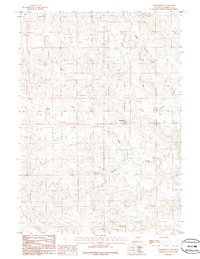
1984 Map of Turnercrest
USGS Topo · Published 1984About this map
Turnercrest serves as the focal point for this 1984 Wyoming survey, situated in a landscape defined by the drainage systems of the Powder River Basin. The convergence of Little Bates Creek, North Bates Creek, and Mexican Springs Creek highlights the essential water sources that have historically shaped ranching and settlement in Campbell County. The presence of a Tank near the township boundary of T 42 N and T 41 N indicates the managed infrastructure necessary for livestock and industrial activity in this semi-arid region. In the eastern portion of the quadrangle, the expansive terrain of Reno Flats underscores the open, low-relief geography characteristic of the northeastern Wyoming plains during the late twentieth century.
Find a feature on this map
7 named features on this map. Tap any name to fly to it.
Don’t see what you’re looking for? This feature index may not catch every label — zoom into the map to look around manually.
Map Details
Editions of this 1984 Turnercrest Map
2 editions found
Other maps of this area

1953 · South Butte
USGS Topo · 1:24,000

1954 · Pine Tree
USGS Topo · 1:24,000

1955 · Newcastle
USGS Topo · 1:250,000

1958 · Newcastle
USGS Topo · 1:250,000

1959 · Coal Draw
USGS Topo · 1:62,500

1960 · Ross
USGS Topo · 1:62,500

1960 · Turnercrest
USGS Topo · 1:62,500

1974 · Reno Junction
USGS Topo · 1:100,000

1979 · Bill
USGS Topo · 1:100,000
1984 · Coal Draw North
USGS Topo · 1:24,000