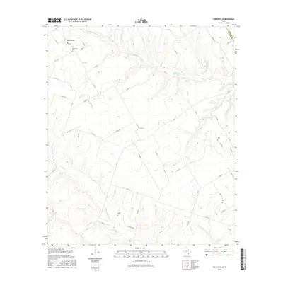
2016 Map of Turnersville
USGS Topo · Published 2016About this map
Turnersville sits at the northern edge of Coryell County, where the watershed is defined by the winding course of the Middle Bosque River and several significant tributaries like Thorp Br and Pickens Br. This 2016 survey shows a landscape of dispersed rural farmsteads connected by a dense network of county roads such as Co RD 233 and Co RD 240. The map is particularly useful for genealogical research, as it identifies several small family or community burial grounds including Miller Cem, Crawford Cem, and Coffee Cem, often located near seasonal watercourses like Cave Cr and Rainey Cr. The boundary with Bosque County is clearly delineated at the map's northeastern corner, showing how the local road system, including FM 217 and FM 182, navigates the complex drainage patterns of the Coryell Cr basin.
Find a feature on this map
58 named features on this map. Tap any name to fly to it.
Don’t see what you’re looking for? This feature index may not catch every label — zoom into the map to look around manually.
Map Details
Editions of this 2016 Turnersville Map
This is the sole edition of this map. No revisions or reprints were ever made.
Other maps of this area

1888 · Meridian
USGS Topo · 1:125,000

1894 · Meridian
USGS Topo · 1:125,000

1894 · Gatesville
USGS Topo · 1:125,000

1947 · Purmela
USGS Topo · 1:62,500

1947 · Oglesby
USGS Topo · 1:24,000

1947 · Gatesville West
USGS Topo · 1:24,000

1947 · Gatesville East
USGS Topo · 1:24,000
1950 · Gatesville
USGS Topo · 1:62,500

1954 · Waco
USGS Topo · 1:250,000
1954 · Gatesville West
USGS Topo · 1:24,000