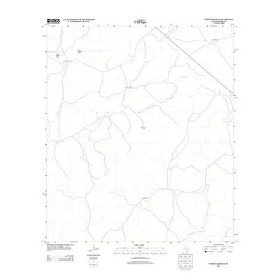
2012 Map of Turney Draw NE
USGS Topo · Published 2012About this map
The ephemeral course of the Dry Devils River winds through this sparsely populated section of Edwards County, defining a landscape of vast ranching operations in the early 21st century. The map records several established family-named holdings, including the Jack Turney Ranch and Paul Turney Ranch, illustrating the continued importance of large-scale land ownership in West Texas. These ranches are connected by a web of unimproved and 4WD roads that follow the natural topography, often intersecting with local drainages like Big Turney Draw and Little Turney Draw. To the northeast, the Wheat Ranch and to the south, the Mayfield Ranch further delineate the rural settlement pattern, where infrastructure is primarily limited to access routes for these sprawling agricultural properties. This survey captures the remote character of the Edward's Plateau just before modern developments further altered the traditional ranching boundaries.
Find a feature on this map
8 named features on this map. Tap any name to fly to it.
Don’t see what you’re looking for? This feature index may not catch every label — zoom into the map to look around manually.
Map Details
Editions of this 2012 Turney Draw NE Map
This is the sole edition of this map. No revisions or reprints were ever made.
Other maps of this area

1893 · Rock Springs
USGS Topo · 1:125,000

1954 · Sonora
USGS Topo · 1:250,000

1958 · Sonora
USGS Topo · 1:250,000

1963 · Harrison Ranch
USGS Topo · 1:24,000

1967 · Dunbar Draw SW
USGS Topo · 1:24,000

1967 · Dunbar Draw SE
USGS Topo · 1:24,000

1970 · Ray Lake NW
USGS Topo · 1:24,000

1971 · Turney Draw SE
USGS Topo · 1:24,000
1971 · Turney Draw NE
USGS Topo · 1:24,000
1971 · Ray Lake SW
USGS Topo · 1:24,000