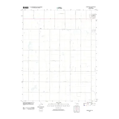
2010 Map of Turpin West
USGS Topo · Published 2010About this map
Nabisco Cemetery sits as a quiet landmark within the section-line grid of the Oklahoma Panhandle, just west of the small community of Turpin. This landscape is defined by the rigid geometry of rural roads like K Rd and M Rd, which divide the high plains into precise squares. Cutting through this artificial order is the natural course of Sharp Creek, which meanders across the northeast corner of the quadrangle. The map reveals the high degree of organization in Beaver County's modern rural infrastructure, where alphanumeric routes such as Hollow E0110 and Hollow N1170 facilitate transport between isolated homesteads and larger agricultural hubs. Scattered across the terrain are numerous small, unnamed water catchments, typical of the regional hydrology in this part of Oklahoma.
Find a feature on this map
24 named features on this map. Tap any name to fly to it.
Don’t see what you’re looking for? This feature index may not catch every label — zoom into the map to look around manually.
Map Details
Editions of this 2010 Turpin West Map
This is the sole edition of this map. No revisions or reprints were ever made.
Other maps of this area

1954 · Perryton
USGS Topo · 1:250,000

1958 · Perryton
USGS Topo · 1:250,000

1967 · Adams
USGS Topo · 1:24,000

1967 · Tyrone
USGS Topo · 1:24,000

1968 · Hardesty NE
USGS Topo · 1:24,000

1973 · Boyd
USGS Topo · 1:24,000

1973 · Little Ponderosa
USGS Topo · 1:24,000

1973 · Turpin East
USGS Topo · 1:24,000

1973 · Red Horse Creek
USGS Topo · 1:24,000
1973 · Turpin NE
USGS Topo · 1:24,000