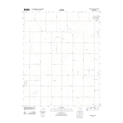
2012 Map of Turpin West
USGS Topo · Published 2012About this map
Turpin sits in the northeastern corner of this Beaver County landscape, where the local economy and geography are defined by a rigid grid of section-line roads and the path of the Wheeler RR 1. The town's layout is centered around local transit and storage, with labels indicating Hellem and Hill alongside the railroad tracks. Outside the immediate settlement, the terrain is marked by the meandering course of Sharp Creek, which provides the only natural deviation from the square-mile blocks of the High Plains.
Find a feature on this map
44 named features on this map. Tap any name to fly to it.
Don’t see what you’re looking for? This feature index may not catch every label — zoom into the map to look around manually.
Map Details
Editions of this 2012 Turpin West Map
This is the sole edition of this map. No revisions or reprints were ever made.
Other maps of this area

1954 · Perryton
USGS Topo · 1:250,000

1958 · Perryton
USGS Topo · 1:250,000

1967 · Adams
USGS Topo · 1:24,000

1967 · Tyrone
USGS Topo · 1:24,000

1968 · Hardesty NE
USGS Topo · 1:24,000

1973 · Boyd
USGS Topo · 1:24,000

1973 · Little Ponderosa
USGS Topo · 1:24,000

1973 · Turpin East
USGS Topo · 1:24,000

1973 · Red Horse Creek
USGS Topo · 1:24,000
1973 · Turpin NE
USGS Topo · 1:24,000