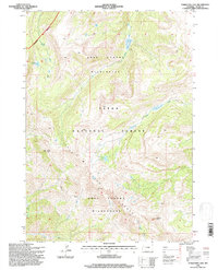
1996 Map of Turquoise Lake
USGS Topo · Published 1998About this map
The Gros Ventre Range dominates this mid-1990s survey, representing a high-elevation backcountry corridor within the Teton National Forest. The landscape is defined by its drainage systems and peaks, with Flat Creek and Granite Creek carving paths through the protected reaches of the Gros Ventre Wilderness. Notable landmarks like Cache Peak and Pinnacle Peak provide orientation for the region's historical trails and seasonal outposts.
Find a feature on this map
15 named features on this map. Tap any name to fly to it.
Don’t see what you’re looking for? This feature index may not catch every label — zoom into the map to look around manually.
Map Details
Editions of this 1996 Turquoise Lake Map
2 editions found
Other maps of this area

1899 · Grand Teton
USGS Topo · 1:125,000

1901 · Grand Teton
USGS Topo · 1:125,000

1902 · Mt Leidy
USGS Topo · 1:125,000

1907 · Gros Ventre
USGS Topo · 1:125,000

1910 · Gros Ventre
USGS Topo · 1:125,000

1931 · Jackson
USGS Topo · 1:125,000

1935 · Jackson
USGS Topo · 1:125,000

1955 · Driggs
USGS Topo · 1:250,000

1958 · Driggs
USGS Topo · 1:250,000

1962 · Driggs
USGS Topo · 1:250,000