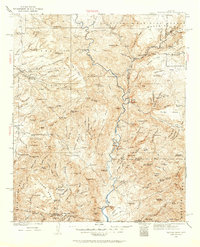
1929 Map of Turret Peak
USGS Topo · Published 1962About this map
The Verde River winds through this Central Arizona landscape surveyed in the late 1920s, a region defined by high mesas and deep-cut canyons at the meeting point of Yavapai and Maricopa counties. Cattle ranching and hard-rock mining anchor the local economy, evidenced by numerous family operations such as the Anchor Ranch, L X Bar Ranch, and Dugan Ranch. The map reveals a cluster of industrial activity in the southwest, where the Copper Queen Mine, United Arizona Mine, and Rosalie Mine operated in the vicinity of Squaw Creek. Higher elevations are marked by the Coconino National Forest and Tonto National Forest boundaries, while local landmarks like Verde Hot Springs and a Ranger Station indicate early forest management and recreational interest. The isolation of places like Bloody Basin and Cooks Mesa underscores the difficult terrain encountered by early surveyors W. G. Carson and C. W. H. Nessler.
Find a feature on this map
138 named features on this map. Tap any name to fly to it.
Don’t see what you’re looking for? This feature index may not catch every label — zoom into the map to look around manually.
Map Details
Editions of this 1929 Turret Peak Map
3 editions found

Other maps of this area

1887 · Verde
USGS Topo · 1:250,000

1887 · Prescott
USGS Topo · 1:250,000

1892 · Verde
USGS Topo · 1:250,000

1892 · Prescott
USGS Topo · 1:250,000

1903 · Bradshaw Mountains
USGS Topo · 1:125,000

1905 · Jerome
USGS Topo · 1:125,000

1907 · Roosevelt
USGS Topo · 1:125,000

1909 · Four Peaks
USGS Topo · 1:125,000

1912 · Roosevelt
USGS Topo · 1:125,000

1923 · Camp Verde
USGS Topo · 1:125,000