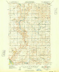
1949 Map of Turtle Creek
USGS Topo · Published 1949About this map
Turtle Creek winds through the heart of McLean Co in this late-1940s topographic record, revealing a rural landscape defined by township school districts and scattered pioneer cemeteries. The map meticulously documents the social fabric of the era through its naming of numerous rural schoolhouses, including the Veeder, New Home, Sverdrup, Koenig, Satterlund, and Iowa systems. These clusters of small educational outposts reflect the high density of family farms before the consolidation of mid-century agriculture.
Find a feature on this map
32 named features on this map. Tap any name to fly to it.
Don’t see what you’re looking for? This feature index may not catch every label — zoom into the map to look around manually.
Map Details
Editions of this 1949 Turtle Creek Map
2 editions found
Other maps of this area

1929 · Coleharbor
USGS Topo · 1:62,500

1945 · Pelican Lake
USGS Topo · 1:62,500

1947 · Pelican Lake
USGS Topo · 1:62,500

1947 · Turtle Lake
USGS Topo · 1:62,500

1949 · Turtle Creek
USGS Topo · 1:62,500

1949 · Washburn
USGS Topo · 1:62,500

1950 · Wilton
USGS Topo · 1:62,500

1954 · McClusky
USGS Topo · 1:250,000

1958 · McClusky
USGS Topo · 1:250,000

1959 · Mercer
USGS Topo · 1:24,000