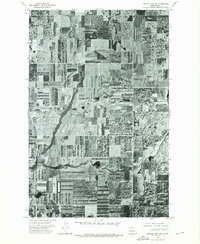
1974 Map of Turtle Lake NW
USGS Topo · Published 1975About this map
Crooked Lake anchors the southeastern corner of this orthophotoquad, which captures the McLean County landscape as it appeared in the mid-1970s. Unlike traditional topographic maps, this aerial perspective reveals the intricate, textured patterns of the region's agricultural heartland. The image provides an uncompromising look at the geometric precision of the Great Plains' section-line farming, where vast rectangular fields are punctuated by natural depressions and seasonal wetlands. This 1974 survey was produced through the cooperation of the State Water Commission, illustrating the vital intersection of prairie land use and water resource management in North Dakota's central drift plains.
Find a feature on this map
1 named feature on this map. Tap any name to fly to it.
Don’t see what you’re looking for? This feature index may not catch every label — zoom into the map to look around manually.
Map Details
Editions of this 1974 Turtle Lake NW Map
This is the sole edition of this map. No revisions or reprints were ever made.
Other maps of this area

1929 · Coleharbor
USGS Topo · 1:62,500

1929 · Benedict
USGS Topo · 1:62,500

1929 · Kongsberg
USGS Topo · 1:62,500

1947 · Turtle Lake
USGS Topo · 1:62,500

1954 · McClusky
USGS Topo · 1:250,000

1958 · McClusky
USGS Topo · 1:250,000

1961 · Turtle Lake
USGS Topo · 1:24,000

1961 · Lake Nettie
USGS Topo · 1:24,000
1961 · Peterson Lake
USGS Topo · 1:24,000

1974 · Benedict SE
USGS Topo · 1:24,000