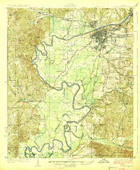
1926 Map of Tuscaloosa
USGS Topo · Published 1926About this map
The Black Warrior River dominates this landscape, winding through a series of dramatic oxbows and named bends like Snows Bend and Hemphill Bend as it passes the growing city of Tuscaloosa. This mid-1920s survey captures the region as it transitions from a river-and-rail hub to an academic and industrial center, featuring the prominent grounds of the University of Alabama and the State Hospital on the eastern bluffs.
Find a feature on this map
82 named features on this map. Tap any name to fly to it.
Don’t see what you’re looking for? This feature index may not catch every label — zoom into the map to look around manually.
Map Details
Editions of this 1926 Tuscaloosa Map
3 editions found
Other maps of this area

1899 · Brookwood
USGS Topo · 1:125,000

1924 · Tuscaloosa
USGS Topo · 1:62,500

1926 · Samantha
USGS Topo · 1:48,000

1926 · Tuscaloosa
USGS Topo · 1:62,500

1927 · Eutaw
USGS Topo · 1:48,000

1928 · Samantha
USGS Topo · 1:62,500

1929 · Searles
USGS Topo · 1:48,000

1931 · Cottondale
USGS Topo · 1:48,000

1931 · Eutaw
USGS Topo · 1:62,500

1934 · Searles
USGS Topo · 1:62,500