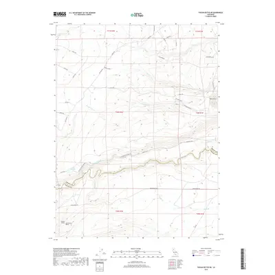
2018 Map of Tuscan Buttes NE
USGS Topo · Published 2018About this map
Battle Creek meanders across the southern landscape of this terrain, marking the boundary between Shasta and Tehama counties. The area is defined by the hydraulic infrastructure of the Coleman Canal and the Coleman Forebay, features linked to regional water management and fishery operations along the canyon. To the east, the volcanic profile of Black Butte stands as a prominent landmark above a network of drainages including Rancheria Creek and Ash Creek. The transition from the higher northern slopes toward the Sacramento Valley floor is evident through the convergence of smaller streams like Lack Creek and Spring Branch. This 2018 survey documents a rural landscape where local routes like Dersch Road and Coleman Fish Hatchery Road provide access to the rugged foothills at the edge of the Central Valley.
Find a feature on this map
40 named features on this map. Tap any name to fly to it.
Don’t see what you’re looking for? This feature index may not catch every label — zoom into the map to look around manually.
Map Details
Editions of this 2018 Tuscan Buttes NE Map
This is the sole edition of this map. No revisions or reprints were ever made.
Other maps of this area
1886 · Lassen Peak
USGS Topo · 1:250,000
1890 · Red Bluff
USGS Topo · 1:250,000
1892 · Lassen Peak
USGS Topo · 1:250,000
1894 · Lassen Peak
USGS Topo · 1:250,000
1894 · Red Bluff
USGS Topo · 1:250,000
1901 · Redding
USGS Topo · 1:125,000
1935 · Burney
USGS Topo · 1:96,000
1935 · Paynes Creek
USGS Topo · 1:96,000
1939 · Burney
USGS Topo · 1:125,000
1941 · Mineral
USGS Topo · 1:125,000