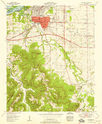
1952 Map of Tuscumbia
USGS Topo · Published 1958About this map
The city of Tuscumbia serves as the focal point of this mid-century survey, revealing the dense urban core and surrounding rural growth at the height of the Tennessee Valley Authority era. Within the city, landmarks like the Courthouse and the Helen Keller Home stand near the Fairgrounds and the Deshler High Sch. The map illustrates the industrial and transit importance of the region, featuring the Southern Railway lines and the Southern Station at the edge of the Tennessee Reservation.
Find a feature on this map
72 named features on this map. Tap any name to fly to it.
Don’t see what you’re looking for? This feature index may not catch every label — zoom into the map to look around manually.
Map Details
Editions of this 1952 Tuscumbia Map
This is the sole edition of this map. No revisions or reprints were ever made.
Other maps of this area

1914 · Muscle Shoals
USGS Topo · 1:48,000

1916 · Muscle Shoals
USGS Topo · 1:62,500

1924 · Tuscumbia
USGS Topo · 1:48,000

1924 · Gravelly Springs
USGS Topo · 1:48,000

1925 · Barton
USGS Topo · 1:62,500

1926 · Tuscumbia
USGS Topo · 1:62,500

1926 · Barton
USGS Topo · 1:48,000

1926 · Gravelly Springs
USGS Topo · 1:62,500

1929 · Barton
USGS Topo · 1:62,500

1936 · Russellville
USGS Topo · 1:24,000