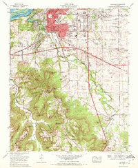
1971 Map of Tuscumbia
USGS Topo · Published 1972About this map
Industrial and urban development define the landscape of the Tennessee River valley as it appeared in the early 1970s. The contiguous cities of Sheffield, Tuscumbia, and Muscle Shoals form a dense corridor of growth, anchored by the Southern Railway and a network of major thoroughfares like the Lee Highway and Jackson Highway. Beyond the urban core, the map reveals a varied topography where the flat valley floors meet the sharp rises of Backbone Mountain and Bald Knob.
Find a feature on this map
92 named features on this map. Tap any name to fly to it.
Don’t see what you’re looking for? This feature index may not catch every label — zoom into the map to look around manually.
Map Details
Editions of this 1971 Tuscumbia Map
This is the sole edition of this map. No revisions or reprints were ever made.
Other maps of this area

1914 · Muscle Shoals
USGS Topo · 1:48,000

1916 · Muscle Shoals
USGS Topo · 1:62,500

1924 · Tuscumbia
USGS Topo · 1:48,000

1924 · Gravelly Springs
USGS Topo · 1:48,000

1925 · Barton
USGS Topo · 1:62,500

1926 · Tuscumbia
USGS Topo · 1:62,500

1926 · Barton
USGS Topo · 1:48,000

1926 · Gravelly Springs
USGS Topo · 1:62,500

1929 · Barton
USGS Topo · 1:62,500

1936 · Russellville
USGS Topo · 1:24,000