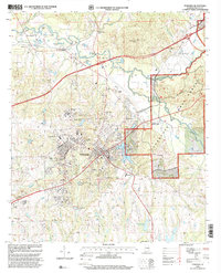
1998 Map of Tuskegee
USGS Topo · Published 2001About this map
Tuskegee Institute and the adjacent Veterans Hospital anchor the central landscape of this late-1990s survey, showing the complex institutional footprint of this historic Alabama community. The mapping detail highlights the intersection of education and public service, with the campus surroundings including Greenwood Cem and Adams Sch. To the north, Moton Field and the settlement of Chehaw sit near the winding course of Uphapee Creek, while the eastern portion of the map is dominated by the dense canopy of the Tuskegee National Forest.
Find a feature on this map
40 named features on this map. Tap any name to fly to it.
Don’t see what you’re looking for? This feature index may not catch every label — zoom into the map to look around manually.
Map Details
Editions of this 1998 Tuskegee Map
This is the sole edition of this map. No revisions or reprints were ever made.
Other maps of this area

1906 · Dadeville
USGS Topo · 1:125,000

1955 · Phenix City
USGS Topo · 1:250,000

1957 · Phenix City
USGS Topo · 1:250,000

1958 · Phenix City
USGS Topo · 1:250,000

1971 · Little Texas
USGS Topo · 1:24,000

1971 · Carrville
USGS Topo · 1:24,000

1971 · Loachapoka
USGS Topo · 1:24,000

1971 · Tuskegee
USGS Topo · 1:24,000
1971 · Notasulga
USGS Topo · 1:24,000

1971 · La Place
USGS Topo · 1:24,000