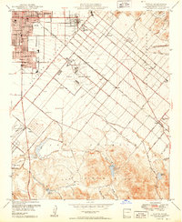
1950 Map of Tustin
USGS Topo · Published 1950About this map
The agricultural and aviation landscape of mid-century Orange County is captured here under the administration of Governor Earl Warren. The city of Santa Ana occupies the northwest corner, giving way to the growing community of Tustin and the expansive Irvine Ranch. A significant Naval Reservation dominates the central plains, its large hangars and runways positioned near the Orange County Airport. This era shows the region before the arrival of the modern freeway system, with travel instead defined by the Atchison Topeka and Santa Fe railroad and local thoroughfares like Newport Avenue. To the south, the terrain rises into the San Joaquin Hills, where water management features like the San Joaquin Dam and Bonita Reservoir supported the irrigation needs of the surrounding citrus and lima bean fields. Several local social landmarks, including the Sprig Gun Club and Aliso Gun Club, dot the open marshlands and washes near the coast.
Find a feature on this map
62 named features on this map. Tap any name to fly to it.
Don’t see what you’re looking for? This feature index may not catch every label — zoom into the map to look around manually.
Map Details
Editions of this 1950 Tustin Map
2 editions found

Other maps of this area

1896 · Santa Ana
USGS Topo · 1:62,500

1896 · Anaheim
USGS Topo · 1:62,500

1898 · Anaheim
USGS Topo · 1:62,500

1901 · Southern California Sheet No. 1
USGS Topo · 1:250,000

1901 · Santa Ana
USGS Topo · 1:62,500

1901 · Anaheim
USGS Topo · 1:62,500

1902 · Corona
USGS Topo · 1:125,000

1904 · Southern California Sheet No. 1
USGS Topo · 1:250,000

1932 · Orange
USGS Topo · 1:31,680

1932 · Newport Beach
USGS Topo · 1:31,680