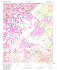
1965 Map of Tustin
USGS Topo · Published 1982About this map
The Marine Corps Air Station (Helicopter) anchors the center of this landscape, illustrating the military's significant footprint in Orange County during the mid-20th century. Bordered by the rapid expansion of Tustin and Santa Ana, the map documents a period of intense transition as agricultural lands like the Irvine Ranch were being reshaped into planned suburban and academic hubs. The newly established University of California (Irvine) appears in the south, while the Santa Ana Freeway and San Diego Freeway define the emerging transportation corridors that fueled the region's growth.
Find a feature on this map
86 named features on this map. Tap any name to fly to it.
Don’t see what you’re looking for? This feature index may not catch every label — zoom into the map to look around manually.
Map Details
Editions of this 1965 Tustin Map
2 editions found
Other maps of this area

1896 · Santa Ana
USGS Topo · 1:62,500

1896 · Anaheim
USGS Topo · 1:62,500

1898 · Anaheim
USGS Topo · 1:62,500

1901 · Southern California Sheet No. 1
USGS Topo · 1:250,000

1901 · Santa Ana
USGS Topo · 1:62,500

1901 · Anaheim
USGS Topo · 1:62,500

1902 · Corona
USGS Topo · 1:125,000

1904 · Southern California Sheet No. 1
USGS Topo · 1:250,000

1932 · Orange
USGS Topo · 1:31,680

1932 · Newport Beach
USGS Topo · 1:31,680