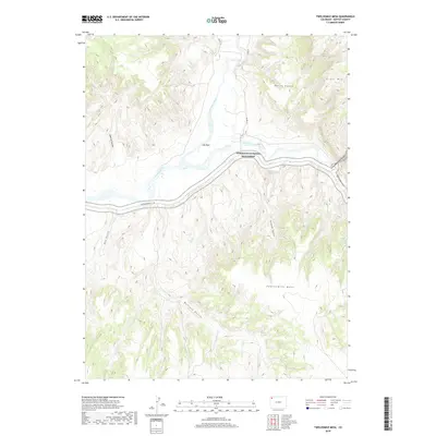
2019 Map of Twelvemile Mesa
USGS Topo · Published 2019About this map
The confluence of the Little Snake River and the Yampa River defines this western Colorado landscape, where the waters meet near the historic settlement area of Lily Park. This high-desert region is dominated by significant elevation changes, from the deep incisions of Cross Mountain Canyon to the broad plateau of Twelvemile Mesa. The northern reaches of Dinosaur National Monument extend into this territory, accessible via the Dinosaur Park Svc Rd, reflecting the area's protected status and geologic importance. Numerous drainages such as Sawmill Canyon, Horse Gulch, and Buffalo Gulch carve through the terrain, illustrating the complex watershed that feeds into the river systems. The presence of Cross Mtn in the northeast provides a prominent landmark for navigating this portion of Moffat County, which remains characterized by its sparse development and significant public land holdings.
Find a feature on this map
20 named features on this map. Tap any name to fly to it.
Don’t see what you’re looking for? This feature index may not catch every label — zoom into the map to look around manually.
Map Details
Editions of this 2019 Twelvemile Mesa Map
This is the sole edition of this map. No revisions or reprints were ever made.
Other maps of this area
1907 · Rangely
USGS Topo · 1:125,000
1907 · White River
USGS Topo · 1:125,000
1910 · White River
USGS Topo · 1:125,000
1910 · Rangely
USGS Topo · 1:125,000

1954 · Vernal
USGS Topo · 1:250,000

1958 · Vernal
USGS Topo · 1:250,000

1960 · Vernal
USGS Topo · 1:250,000
1960 · Elk Springs
USGS Topo · 1:62,500
1960 · Lone Mountain
USGS Topo · 1:62,500
1962 · M F Mountain
USGS Topo · 1:24,000