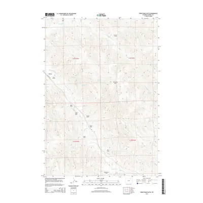
2015 Map of Twentymile Butte
USGS Topo · Published 2015About this map
Twentymile Butte rises as the central landmark of this Campbell County high-plains landscape, where a complex network of draws and seasonal creeks dictates the geography of the Powder River Basin. The small settlement of Echeta sits along W Echeta Rd in the west, serving as a focal point for the surrounding ranching and range land. The drainage patterns are well-defined, with Wild Horse Cr and Twentymile Cr carving through the terrain alongside numerous named gullies such as Little Cedar Draw, Barker Draw, and Felix Draw. Resource management is evident at the Echetah Reservoir, a vital water source in this semi-arid environment. The map captures a moment in the mid-2010s where traditional land use patterns, including the Public Land Survey System boundaries like t52n r75w, remain the primary framework for local navigation and property.
Find a feature on this map
23 named features on this map. Tap any name to fly to it.
Don’t see what you’re looking for? This feature index may not catch every label — zoom into the map to look around manually.
Map Details
Editions of this 2015 Twentymile Butte Map
This is the sole edition of this map. No revisions or reprints were ever made.
Other maps of this area

1954 · Gillette
USGS Topo · 1:250,000

1955 · Gillette
USGS Topo · 1:250,000

1958 · Gillette
USGS Topo · 1:250,000

1962 · Gillette
USGS Topo · 1:250,000
1971 · Wildcat
USGS Topo · 1:24,000
1971 · Oriva NW
USGS Topo · 1:24,000
1971 · Oriva
USGS Topo · 1:24,000
1971 · Truman Draw
USGS Topo · 1:24,000
1972 · Carr Draw
USGS Topo · 1:24,000
1972 · Jeffers Draw
USGS Topo · 1:24,000