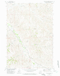
1972 Map of Twentymile Butte
USGS Topo · Published 1975About this map
Wild Horse Creek snakes through the high plains of Campbell County, carving a corridor for the Burlington Northern railroad in the early 1970s. This land, mapped as part of the Department of the Interior's Missouri River Basin development program, is defined by an intricate network of drainage draws and intermittent streams such as Mooney Draw and Barker Draw. The small settlement of Felix and the rail-stop at Echeta anchor the human geography, while landmarks like Twentymile Butte provide vertical orientation in a landscape shaped by erosion.
Find a feature on this map
22 named features on this map. Tap any name to fly to it.
Don’t see what you’re looking for? This feature index may not catch every label — zoom into the map to look around manually.
Map Details
Editions of this 1972 Twentymile Butte Map
This is the sole edition of this map. No revisions or reprints were ever made.
Other maps of this area

1954 · Gillette
USGS Topo · 1:250,000

1955 · Gillette
USGS Topo · 1:250,000

1958 · Gillette
USGS Topo · 1:250,000

1962 · Gillette
USGS Topo · 1:250,000

1971 · Wildcat
USGS Topo · 1:24,000

1971 · Oriva NW
USGS Topo · 1:24,000

1971 · Oriva
USGS Topo · 1:24,000
1971 · Truman Draw
USGS Topo · 1:24,000
1972 · Carr Draw
USGS Topo · 1:24,000
1972 · Jeffers Draw
USGS Topo · 1:24,000