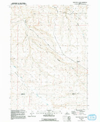
1992 Map of Twentymile Butte
USGS Topo · Published 1992About this map
The historical Oregon Trail cuts across this high desert landscape, tracing a path through the northern reaches of the quadrangle. The map captures a transition between the elevated Flint Mesa and the wide expanse of Deadman Flat, a region defined by its complex drainage systems including Rosevear Gulch and Deadman Creek. The interior is crisscrossed by essential ranching and transit infrastructure, such as the Bell Rapids Road and a solitary Water Tank, reflecting the area's agricultural and logistical importance at the boundary of Elmore and Owyhee counties. The namesake Twentymile Butte stands as a prominent navigational landmark overlooking the deep gulches and arid plateaus that characterize this southern Idaho territory in the early 1990s.
Find a feature on this map
14 named features on this map. Tap any name to fly to it.
Don’t see what you’re looking for? This feature index may not catch every label — zoom into the map to look around manually.
Map Details
Editions of this 1992 Twentymile Butte Map
This is the sole edition of this map. No revisions or reprints were ever made.
Other maps of this area

1947 · Glenns Ferry
USGS Topo · 1:24,000

1947 · Pasadena Valley
USGS Topo · 1:24,000

1948 · Pasadena Valley
USGS Topo · 1:24,000

1948 · Glenns Ferry
USGS Topo · 1:24,000

1948 · Twentymile Butte
USGS Topo · 1:24,000

1948 · Glenns Ferry
USGS Topo · 1:62,500

1948 · Ticeska
USGS Topo · 1:24,000

1948 · Grindstone Butte
USGS Topo · 1:24,000
1949 · Grindstone Butte
USGS Topo · 1:24,000

1949 · Ticeska
USGS Topo · 1:24,000