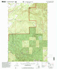
1996 Map of Twentymile Creek
USGS Topo · Published 1999About this map
Paradise Valley marks the northern extent of this landscape, where the terrain rises sharply into the protected reaches of the Kaniksu National Forest. This 1996 revision, based on surveys dating back to the 1960s, documents a high-altitude wilderness defined by the Boundary and Bonner County line. The hydrology is centered on Twentymile Creek and its tributaries, including Wishbone Creek and Contrary Creek, which carve deep drainages between prominent summits like Twentymile Peak and Bald Eagle Mountain. Evidence of modern infrastructure is sparse but notable, including a water transmission line, a pipeline, and an Electronic Site near Black Mountain. For those studying the geography of Northern Idaho, the map details numerous high passes such as Twentymile Pass, Beaver Dam Pass, and Kelly Pass, alongside local landmarks like Beaver Lake and a Gravel Pit near the valley floor.
Find a feature on this map
24 named features on this map. Tap any name to fly to it.
Don’t see what you’re looking for? This feature index may not catch every label — zoom into the map to look around manually.
Map Details
Editions of this 1996 Twentymile Creek Map
This is the sole edition of this map. No revisions or reprints were ever made.
Other maps of this area

1911 · Priest Lake
USGS Topo · 1:250,000

1913 · Priest Lake
USGS Topo · 1:250,000

1951 · Mt Pend Oreille
USGS Topo · 1:62,500

1951 · Elmira
USGS Topo · 1:62,500

1958 · Sandpoint
USGS Topo · 1:250,000

1963 · Sandpoint
USGS Topo · 1:250,000

1965 · Twentymile Creek
USGS Topo · 1:24,000

1965 · Moravia
USGS Topo · 1:24,000
1965 · Moyie Springs
USGS Topo · 1:24,000

1965 · Naples
USGS Topo · 1:24,000