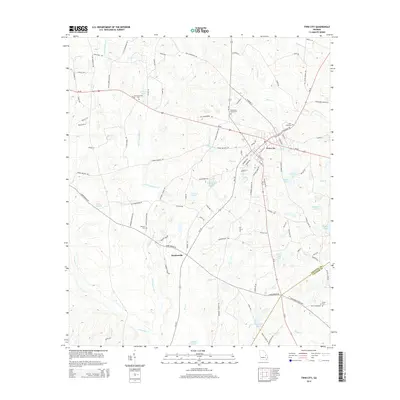
2014 Map of Twin City
USGS Topo · Published 2014About this map
Twin City and the small settlement of Durdenville anchor this Emanuel County landscape, where the local road network and land use patterns are defined by the winding paths of Little Canoochee Cr and the larger Canoochee Cr. The area is notably dotted with numerous small lakes and ponds, including Whitefield Lake, Hudson Lake, and Durden Pond, which served the agricultural and residential needs of the early 21st-century community. Genealogists will find significant value in the distribution of family-named landmarks and burial sites such as the Old Canoochee Cem, Lanier Cem, and Roundtree Grove Cem. The map illustrates the convergence of Us-80 and local routes like Ga-192, showing how these thoroughfares connected dispersed farmsteads to the municipal center of Twin City. This survey provides a clear view of the rural transition into the Emanuel County and Candler County border region, characterized by its slow-moving branches like Alligator Br.
Find a feature on this map
97 named features on this map. Tap any name to fly to it.
Don’t see what you’re looking for? This feature index may not catch every label — zoom into the map to look around manually.
Map Details
Editions of this 2014 Twin City Map
This is the sole edition of this map. No revisions or reprints were ever made.
Other maps of this area

1957 · Macon
USGS Topo · 1:250,000

1958 · Macon
USGS Topo · 1:250,000

1964 · Macon
USGS Topo · 1:250,000
1970 · Metter
USGS Topo · 1:24,000

1970 · Nunez
USGS Topo · 1:24,000

1971 · Stillmore
USGS Topo · 1:24,000

1971 · Swainsboro
USGS Topo · 1:24,000

1971 · Twin City
USGS Topo · 1:24,000
1971 · Twin City SE
USGS Topo · 1:24,000
1971 · Garfield
USGS Topo · 1:24,000