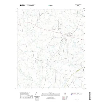
2020 Map of Twin City
USGS Topo · Published 2020About this map
The town of Twin City serves as the focal point of this Emanuel County landscape, where the confluence of regional history and hydrology is etched into the terrain. The area is defined by the winding paths of Little Canoochee Cr and Canoochee Cr, which feed a series of water bodies including Hudson Lake, Coleman Lake, and Whitefield Lake. To the south, the settlement of Durdenville sits near the crossing of Thick Creek and Alligator Br, illustrating the historical reliance on local watercourses for rural positioning.
Find a feature on this map
102 named features on this map. Tap any name to fly to it.
Don’t see what you’re looking for? This feature index may not catch every label — zoom into the map to look around manually.
Map Details
Editions of this 2020 Twin City Map
This is the sole edition of this map. No revisions or reprints were ever made.
Other maps of this area

1957 · Macon
USGS Topo · 1:250,000

1958 · Macon
USGS Topo · 1:250,000

1964 · Macon
USGS Topo · 1:250,000
1970 · Metter
USGS Topo · 1:24,000

1970 · Nunez
USGS Topo · 1:24,000

1971 · Stillmore
USGS Topo · 1:24,000

1971 · Swainsboro
USGS Topo · 1:24,000

1971 · Twin City
USGS Topo · 1:24,000
1971 · Twin City SE
USGS Topo · 1:24,000
1971 · Garfield
USGS Topo · 1:24,000