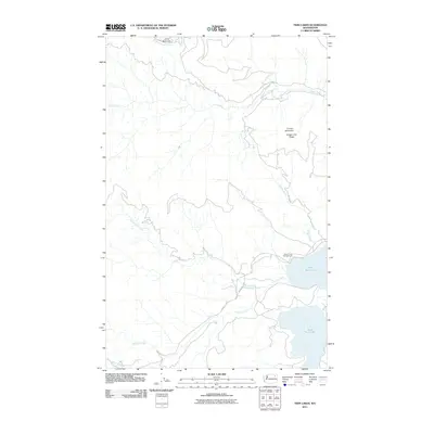
2011 Map of Twin Lakes
USGS Topo · Published 2011About this map
North Twin Lake and South Twin Lake dominate the eastern landscape of this Ferry County region, providing a significant water system for the surrounding high country. The terrain is defined by prominent elevations such as Johns Mountain in the northwest and Carson Mountain overlooking Oregon City Ridge. This area is heavily dissected by drainage networks, including the long course of Lynx Creek and the southern flow of Granite Creek. Modern accessibility is noted through routes like County Hwy 2 and Wyencoop Rd, which link the interior mountains to the recreation site at Rocky Point Campground. The map illustrates a rural, mountainous environment where natural hydrology and timbered ridges dictate the placement of local infrastructure and forest roads.
Find a feature on this map
16 named features on this map. Tap any name to fly to it.
Don’t see what you’re looking for? This feature index may not catch every label — zoom into the map to look around manually.
Map Details
Editions of this 2011 Twin Lakes Map
This is the sole edition of this map. No revisions or reprints were ever made.
Other maps of this area

1948 · Wilmont Creek
USGS Topo · 1:62,500

1950 · Wilmont Creek
USGS Topo · 1:62,500

1952 · Keller
USGS Topo · 1:62,500

1952 · Twin Lakes
USGS Topo · 1:62,500

1953 · Seventeenmile Mtn.
USGS Topo · 1:62,500

1954 · Okanogan
USGS Topo · 1:250,000

1956 · Wilmont Creek
USGS Topo · 1:62,500

1958 · Okanogan
USGS Topo · 1:250,000

1984 · Nespelem
USGS Topo · 1:100,000
1985 · Moon Mountain
USGS Topo · 1:24,000