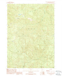
1989 Map of Twin Lakes Mountain
USGS Topo · Published 1990About this map
Umpqua National Forest defines this high-elevation landscape, where the 1989 topography reveals a network of water and seasonal high-country outposts. Twin Lakes Mountain serves as a prominent landmark overlooking Twin Lakes and several upland meadows, including Sheep Prairie and Cow Prairie. The drainage system is particularly well-defined, with Copeland Creek branching into its eastern and western forks, while Boze Creek and French Creek flow through the southern reaches. Evidence of human activity in this wilderness is concentrated at locations like Stroubs Mine and a series of backcountry refuges such as Buckhead Camp, Boze Shelter, and a Shelter near the northern lakes. The presence of Deer Lick Falls and Bear Wallows suggests a landscape largely shaped by its natural hydrology and wildlife corridors, captured here before modern digital updates shifted the mapping of these remote Oregon reaches.
Find a feature on this map
31 named features on this map. Tap any name to fly to it.
Don’t see what you’re looking for? This feature index may not catch every label — zoom into the map to look around manually.
Map Details
Editions of this 1989 Twin Lakes Mountain Map
This is the sole edition of this map. No revisions or reprints were ever made.
Other maps of this area

1917 · Diamond Lake
USGS Topo · 1:125,000

1955 · Quartz Mtn
USGS Topo · 1:62,500

1955 · Illahee Rock
USGS Topo · 1:62,500

1956 · Toketee Falls
USGS Topo · 1:62,500

1956 · Garwood Butte
USGS Topo · 1:62,500

1958 · Roseburg
USGS Topo · 1:250,000

1959 · Roseburg
USGS Topo · 1:250,000

1978 · Diamond Lake
USGS Topo · 1:100,000
1986 · Toketee Falls
USGS Topo · 1:24,000
1989 · Acker Rock
USGS Topo · 1:24,000