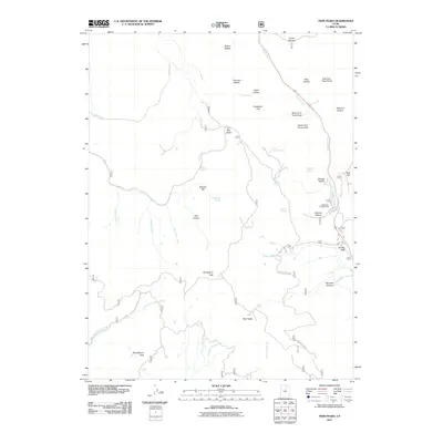
2011 Map of Twin Peaks
USGS Topo · Published 2011About this map
Strawberry Peak and the high points of Twin Peaks anchor this mountainous section of Wasatch County, where the hydrology flows toward both the Hobble Creek and Daniels Creek systems. The landscape is defined by its numerous canyons and hollows, including Pete Canyon and Murdock Hollow, which provide a detailed look at the drainage patterns of the southern Uinta range. The road network centers on the crossing at Daniels Pass, a critical transition point between high ridges like Strawberry Ridge and the lower basin drainage. Local navigation is marked by specific named water sources such as Willow Spring, Burnt Stump Spring, and Mule Ear Spring, which were vital for the early ranching and forestry activities in the area. The presence of the Lodge Pole Campground near the confluence of the North Fork Three Forks and South Fork Three Forks indicates the long-standing recreational utility of these highlands.
Find a feature on this map
40 named features on this map. Tap any name to fly to it.
Don’t see what you’re looking for? This feature index may not catch every label — zoom into the map to look around manually.
Map Details
Editions of this 2011 Twin Peaks Map
This is the sole edition of this map. No revisions or reprints were ever made.
Other maps of this area

1885 · Salt Lake
USGS Topo · 1:250,000

1907 · Strawberry Valley
USGS Topo · 1:125,000

1909 · Strawberry Valley
USGS Topo · 1:125,000

1954 · Salt Lake City
USGS Topo · 1:250,000

1958 · Salt Lake City
USGS Topo · 1:250,000

1960 · Salt Lake City
USGS Topo · 1:250,000

1966 · Strawberry Reservoir NW
USGS Topo · 1:24,000
1966 · Charleston
USGS Topo · 1:24,000

1967 · Two Tom Hill
USGS Topo · 1:24,000
1967 · Granger Mtn
USGS Topo · 1:24,000