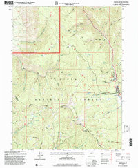
1998 Map of Twin Peaks
USGS Topo · Published 2000About this map
Strawberry Ridge and the high summits of the Uinta National Forest define this 1990s-era landscape in Wasatch County. The map details a complex network of canyons and high benches, including Daniels Canyon and Row Bench, which have historically facilitated movement across this part of the Wasatch Range. The topography is marked by significant elevations like Strawberry Peak and the namesake Twin Peaks, while the presence of the Uinta and Ouray Indian Reservation Boundary reflects the region's complex administrative and cultural history.
Find a feature on this map
50 named features on this map. Tap any name to fly to it.
Don’t see what you’re looking for? This feature index may not catch every label — zoom into the map to look around manually.
Map Details
Editions of this 1998 Twin Peaks Map
This is the sole edition of this map. No revisions or reprints were ever made.
Other maps of this area

1885 · Salt Lake
USGS Topo · 1:250,000

1907 · Strawberry Valley
USGS Topo · 1:125,000

1909 · Strawberry Valley
USGS Topo · 1:125,000

1954 · Salt Lake City
USGS Topo · 1:250,000

1958 · Salt Lake City
USGS Topo · 1:250,000

1960 · Salt Lake City
USGS Topo · 1:250,000

1966 · Strawberry Reservoir NW
USGS Topo · 1:24,000
1966 · Charleston
USGS Topo · 1:24,000

1967 · Two Tom Hill
USGS Topo · 1:24,000
1967 · Granger Mtn
USGS Topo · 1:24,000