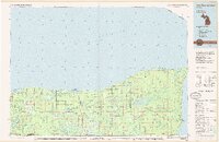
1985 Map of Two Hearted River
USGS Topo · Published 1985About this map
Lake Superior dominates the northern horizon of this Upper Peninsula survey, where the rugged shoreline stretches from the Grand Marais Harbor eastward toward Whitefish Bay. The landscape is defined by vast protected areas, including the Superior State Forest and Tahquamenon Falls State Park, with the iconic Two Hearted River winding through the central timberlands. Small settlements and specialized junctions like Deer Park, Pine Stump Junction, and Lavender Corner punctuate the inland woods, often connected by routes labeled simply as Grade or Old Grade, hinting at the region's logging heritage. Further east, the fishing and timbering history of the area is represented by Paradise and the riverside site of Emerson, while prominent natural features like Betsy Lake and Tahquamenon Falls mark the transition toward the bay. This map provides a look at the mid-1980s configuration of these remote Lake Superior coastal lands.
Find a feature on this map
108 named features on this map. Tap any name to fly to it.
Don’t see what you’re looking for? This feature index may not catch every label — zoom into the map to look around manually.
Map Details
Editions of this 1985 Two Hearted River Map
2 editions found
Other maps of this area

1931 · Seney NW
USGS Topo · 1:31,680

1931 · Driggs Lake NE
USGS Topo · 1:31,680

1941 · Strongs
USGS Topo · 1:63,360

1951 · Vermilion SE
USGS Topo · 1:24,000

1951 · Shelldrake
USGS Topo · 1:24,000

1951 · Vermilion
USGS Topo · 1:24,000

1951 · McNearney Lake
USGS Topo · 1:24,000

1951 · Sheephead Lake
USGS Topo · 1:24,000

1951 · Emerson
USGS Topo · 1:24,000

1951 · Piatt Lake
USGS Topo · 1:24,000