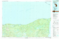
1985 Map of Two Hearted River
USGS Topo · Published 1989About this map
The Two Hearted River flows through the dense timberlands of Michigan’s Upper Peninsula in this mid-1980s landscape, illustrating a region defined by its relationship with Lake Superior. The map details the complex drainage systems of the Tahquamenon River and the Shelldrake River, which navigate a terrain of extensive state forests and wetlands. Coastal landmarks such as Whitefish Point and Crisp Point stand as sentinel features along the shoreline, marking the treacherous transition between the land and the vast waters of Whitefish Bay.
Find a feature on this map
87 named features on this map. Tap any name to fly to it.
Don’t see what you’re looking for? This feature index may not catch every label — zoom into the map to look around manually.
Map Details
Editions of this 1985 Two Hearted River Map
2 editions found
Other maps of this area

1931 · Seney NW
USGS Topo · 1:31,680

1931 · Driggs Lake NE
USGS Topo · 1:31,680

1941 · Strongs
USGS Topo · 1:63,360

1951 · Vermilion SE
USGS Topo · 1:24,000

1951 · Shelldrake
USGS Topo · 1:24,000

1951 · Vermilion
USGS Topo · 1:24,000

1951 · McNearney Lake
USGS Topo · 1:24,000

1951 · Sheephead Lake
USGS Topo · 1:24,000

1951 · Emerson
USGS Topo · 1:24,000

1951 · Piatt Lake
USGS Topo · 1:24,000