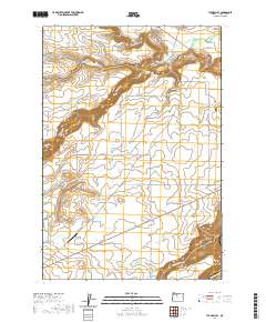
2020 Map of Tygh Valley
USGS Topo · Published 2020About this map
Tygh Valley and the surrounding high plateau of Juniper Flat are the central focus of this Wasco County landscape. The topography is defined by the dramatic incision of the White Wild and Scenic River as it carves through the volcanic terrain toward its confluence with the Deschutes Wild and Scenic River in the southeast corner. Settlement patterns follow the water and the historic road networks, with the community of Pine Hollow situated near Threemile Creek. Genealogists will find the Independent Order of Odd Fellows Cemetery near the valley floor and the Kelly Cemetery further south on the flat. The map illustrates a sophisticated irrigation and transportation network, from the Wapinitia Canal and Wapinitia Airport to various rural routes like Wamic Market Road and Old Wapinitia Road, reflecting the area's agricultural foundation.
Find a feature on this map
46 named features on this map. Tap any name to fly to it.
Don’t see what you’re looking for? This feature index may not catch every label — zoom into the map to look around manually.
Map Details
Editions of this 2020 Tygh Valley Map
This is the sole edition of this map. No revisions or reprints were ever made.
Other maps of this area

1930 · Dufur
USGS Topo · 1:125,000

1934 · Dufur
USGS Topo · 1:125,000

1953 · The Dalles
USGS Topo · 1:250,000

1956 · The Dalles
USGS Topo · 1:250,000

1957 · The Dalles
USGS Topo · 1:250,000

1962 · Sherars Bridge
USGS Topo · 1:24,000

1962 · Postage Stamp Butte
USGS Topo · 1:24,000
1962 · Dant
USGS Topo · 1:24,000

1962 · Wamic
USGS Topo · 1:24,000
1962 · Wapinitia
USGS Topo · 1:24,000