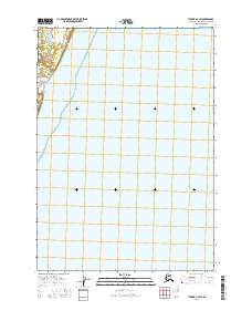
2016 Map of Tyonek A-3 SW
USGS Topo · Published 2016About this map
Pacific Ocean waters and the coastal wetlands of Chuit Flats dominate this coastal expanse along the northwest shore of the Cook Inlet. The landscape is defined by its transition from the marine environment to the low-lying, marshy terrain that characterizes this portion of the Kenai Peninsula. Modern infrastructure is limited to the northern edge of the map, where the Beluga Highway and Pan Am Road provide critical overland access through the region. This 2016 survey illustrates the sparse, industrial-scale transportation network required to navigate the tidal flats and marshy ground of the Alaskan coast, marking a stark contrast between the open water and the undeveloped interior terrain.
Find a feature on this map
6 named features on this map. Tap any name to fly to it.
Don’t see what you’re looking for? This feature index may not catch every label — zoom into the map to look around manually.
Map Details
Editions of this 2016 Tyonek A-3 SW Map
This is the sole edition of this map. No revisions or reprints were ever made.
Other maps of this area

1944 · Kenai
USGS Topo · 1:250,000

1949 · Tyonek
USGS Topo · 1:250,000

1950 · Kenai
USGS Topo · 1:250,000

1950 · Kenai D-4
USGS Topo · 1:63,360

1951 · Tyonek
USGS Topo · 1:250,000

1951 · Kenai D-3
USGS Topo · 1:63,360

1952 · Kenai D-3
USGS Topo · 1:63,360

1952 · Kenai D-4
USGS Topo · 1:63,360

1958 · Tyonek A-4
USGS Topo · 1:63,360
1958 · Tyonek A-3
USGS Topo · 1:63,360