
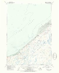
1952 Map of Kenai D-3
USGS Topo · Published 1954About this map
Kenai National Moose Range dominates the interior landscape of this early 1950s survey, revealing a complex network of wetlands and small lakes that define the peninsula's hydrology. The coast along Cook Inlet is marked by expansive Tidal Flats and notable geological markers like Gray Cliff. Remote human presence is recorded sparingly through isolated structures, including a Cabin near the mouth of the Swanson River and a Cabin (Aban'd) further north along the shore. This period of mapping captures the region shortly after the establishment of the national moose range, highlighting a wilderness landscape where drainage patterns like Otter Creek and Bishop Creek were the primary landmarks. The presence of Number Three Bay and Birch Hill provides essential orientation points for those studying the mid-century shoreline before modern development.
Find a feature on this map
12 named features on this map. Tap any name to fly to it.
Don’t see what you’re looking for? This feature index may not catch every label — zoom into the map to look around manually.
Map Details
Editions of this 1952 Kenai D-3 Map
2 editions found
Other maps of this area

1944 · Kenai
USGS Topo · 1:250,000

1949 · Tyonek
USGS Topo · 1:250,000

1950 · Kenai
USGS Topo · 1:250,000

1950 · Kenai C-3
USGS Topo · 1:63,360

1950 · Kenai D-4
USGS Topo · 1:63,360

1951 · Tyonek
USGS Topo · 1:250,000

1951 · Kenai D-3
USGS Topo · 1:63,360

1951 · Kenai C-2
USGS Topo · 1:63,360

1951 · Kenai D-2
USGS Topo · 1:63,360

1951 · Tyonek A-2
USGS Topo · 1:63,360