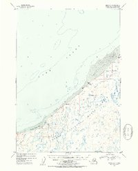
1952 Map of Kenai D-3
USGS Topo · Published 1954About this map
The Kenai National Moose Range dominates the interior of this coastal survey, reflecting early 1950s efforts to manage and protect Alaskan wildlife habitats. The shoreline along Cook Inlet is defined by a wide stretch of Tidal Flats and prominent coastal features like Gray Cliff. This period of topographic mapping reveals a landscape still largely defined by its natural hydrology, with the Swanson River and Otter Creek winding through the lowlands. Human presence is minimal and transient, marked only by isolated landmarks such as a remote Cabin and another identified as Cabin (Aban'd) near the coast. These small structures and the VABM 88 Rok survey marker provide rare fixed points for researchers tracing the historical footprint of early homesteading or seasonal activity in the region during the mid-twentieth century.
Find a feature on this map
12 named features on this map. Tap any name to fly to it.
Don’t see what you’re looking for? This feature index may not catch every label — zoom into the map to look around manually.
Map Details
Editions of this 1952 Kenai D-3 Map
2 editions found

Other maps of this area

1944 · Kenai
USGS Topo · 1:250,000

1949 · Tyonek
USGS Topo · 1:250,000

1950 · Kenai
USGS Topo · 1:250,000

1950 · Kenai C-3
USGS Topo · 1:63,360

1950 · Kenai D-4
USGS Topo · 1:63,360

1951 · Tyonek
USGS Topo · 1:250,000

1951 · Kenai D-3
USGS Topo · 1:63,360

1951 · Kenai C-2
USGS Topo · 1:63,360

1951 · Kenai D-2
USGS Topo · 1:63,360

1951 · Tyonek A-2
USGS Topo · 1:63,360