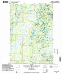
1993 Map of Tyonek C-1
USGS Topo · Published 2002About this map
The Susitna River and the braided channels of the Kroto Slough dominate this Alaskan landscape, where the shifting waters create the complex Delta Islands and a network of wetlands. In the northeast, the Parks Highway provides a critical corridor of development near Willow Lake and the Willow Airport, connecting this wilderness to the broader state infrastructure. The map records a transition from the structured State Recreation Area at Nancy Lake to the vast tracts of interior wilderness characterized by unnamed Cabins and traditional transit routes. Historians will find particular interest in the Iditarod Trail (Approximate) winding through the southern reaches, marking the legacy of dog sled freighting across the Susitna Valley. The area is dotted with family-named water bodies like Shem Pete Lake and Kellys Lake, reflecting the early 20th-century homesteading and trapping history that preceded the area's modern recreational use.
Find a feature on this map
120 named features on this map. Tap any name to fly to it.
Don’t see what you’re looking for? This feature index may not catch every label — zoom into the map to look around manually.
Map Details
Editions of this 1993 Tyonek C-1 Map
This is the sole edition of this map. No revisions or reprints were ever made.
Other maps of this area

1949 · Tyonek
USGS Topo · 1:250,000

1949 · Anchorage D-8
USGS Topo · 1:63,360

1950 · Anchorage C-8
USGS Topo · 1:63,360

1951 · Anchorage
USGS Topo · 1:250,000

1951 · Tyonek
USGS Topo · 1:250,000

1951 · Anchorage D-8
USGS Topo · 1:63,360

1952 · Anchorage C-8
USGS Topo · 1:63,360

1952 · Tyonek D-1
USGS Topo · 1:63,360

1952 · Tyonek C-1
USGS Topo · 1:63,360

1952 · Anchorage D-8
USGS Topo · 1:63,360