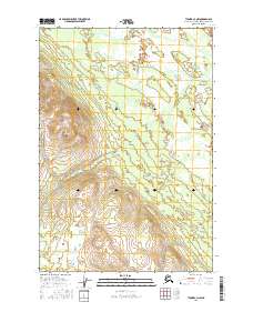
2016 Map of Tyonek C-3 NW
USGS Topo · Published 2016About this map
Beluga Mtn dominates the southwestern quadrant of this Alaskan landscape, providing a topographical anchor for a region defined by complex drainage patterns and high-elevation water systems. The map details a wild, unpopulated territory within the Matanuska-Susitna Borough where the Wolf Lakes cluster at the base of the mountain's eastern slopes. The hydrological network is well-documented, showing the headwaters and meandering paths of Texas Cr in the north and the descent of Bear Cr and Clear Cr. This 2016 survey reflects the modern topographical state of these remote uplands, charting the interplay between the steep relief of the mountain and the surrounding wetlands and creek beds.
Find a feature on this map
9 named features on this map. Tap any name to fly to it.
Don’t see what you’re looking for? This feature index may not catch every label — zoom into the map to look around manually.
Map Details
Editions of this 2016 Tyonek C-3 NW Map
This is the sole edition of this map. No revisions or reprints were ever made.
Other maps of this area

1949 · Tyonek
USGS Topo · 1:250,000

1951 · Tyonek
USGS Topo · 1:250,000

1954 · Tyonek D-3
USGS Topo · 1:63,360

1954 · Tyonek C-4
USGS Topo · 1:63,360

1954 · Tyonek D-4
USGS Topo · 1:63,360

1954 · Tyonek C-3
USGS Topo · 1:63,360

1958 · Tyonek
USGS Topo · 1:250,000

1965 · Tyonek
USGS Topo · 1:250,000
1993 · Tyonek D-3
USGS Topo · 1:63,360
1993 · Tyonek D-4
USGS Topo · 1:63,360