
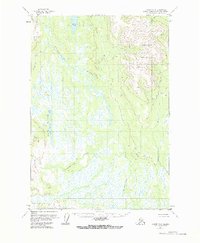
1954 Map of Tyonek C-4
USGS Topo · Published 1961About this map
Beluga Mountain dominates the eastern horizon of this interior Alaskan landscape, which was mapped from aerial photography taken in the early 1950s. The region is defined by a complex network of wetlands and waterways, primarily the meandering Talachulitna River and its tributary, Talachulitna Creek. The drainage patterns here are intricate, with numerous glacial lakes including Hiline Lake, Movie Lake, and Kitty Lake punctuating the low-lying muskeg. Evidence of human presence is sparse, restricted to isolated Cabin locations that likely served as seasonal shelters for hunters or trappers. The terrain transitions sharply from the saturated flats surrounding Trinity Lakes to the rising alpine slopes of the Beluga range, where named drainages like Deep Creek, Bear Creek, and Texas Creek begin their descent.
Find a feature on this map
15 named features on this map. Tap any name to fly to it.
Don’t see what you’re looking for? This feature index may not catch every label — zoom into the map to look around manually.
Map Details
Editions of this 1954 Tyonek C-4 Map
2 editions found
Other maps of this area

1949 · Tyonek
USGS Topo · 1:250,000

1951 · Tyonek
USGS Topo · 1:250,000

1954 · Tyonek D-3
USGS Topo · 1:63,360

1954 · Tyonek C-5
USGS Topo · 1:63,360

1954 · Tyonek B-4
USGS Topo · 1:63,360

1954 · Tyonek D-5
USGS Topo · 1:63,360

1954 · Tyonek D-4
USGS Topo · 1:63,360

1954 · Tyonek C-3
USGS Topo · 1:63,360

1958 · Tyonek B-3
USGS Topo · 1:63,360

1958 · Tyonek B-5
USGS Topo · 1:63,360