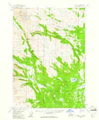
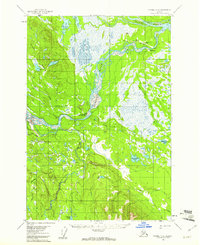
1954 Map of Tyonek C-5
USGS Topo · Published 1961About this map
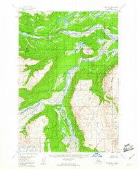
Talachulitna Lake and the larger Judd Lake anchor this mid-century survey of the remote Alaska interior. The landscape is defined by a complex drainage system where Talachulitna Creek and Coal Creek navigate through numerous ridges, including the high points of VABM Tal 4094 and VABM Trum 3101. While primarily a wilderness study, signs of human activity and resource exploration are present in the northern reaches, most notably a Mine located near Alder Creek and a nearby Airstrip. Small Cabins and a lone Cabin at Aho Lake indicate seasonal camps or isolated outposts in an era when access was largely dependent on air travel or river travel. The map captures the watershed before significant modern development, showing the original course of streams like Saturday Creek and Friday Creek as they flow toward the Susitna basin.
Find a feature on this map
18 named features on this map. Tap any name to fly to it.
Don’t see what you’re looking for? This feature index may not catch every label — zoom into the map to look around manually.
Map Details
Editions of this 1954 Tyonek C-5 Map
2 editions found

Other maps of this area

1949 · Tyonek
USGS Topo · 1:250,000

1951 · Tyonek
USGS Topo · 1:250,000
1954 · Tyonek C-4
USGS Topo · 1:63,360
1954 · Tyonek B-4
USGS Topo · 1:63,360
1954 · Tyonek D-5
USGS Topo · 1:63,360
1954 · Tyonek D-4
USGS Topo · 1:63,360
1958 · Tyonek C-6
USGS Topo · 1:63,360
1958 · Tyonek B-5
USGS Topo · 1:63,360
1958 · Tyonek B-6
USGS Topo · 1:63,360
1958 · Tyonek D-6
USGS Topo · 1:63,360