
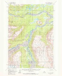
1958 Map of Tyonek D-6
USGS Topo · Published 1961About this map
Skwentna River and the braided glacial drainages of the Susitna Basin dominate this 1950s landscape, captured before extensive modern development. The map reveals a complex network of waterways, including the Hayes River and Trimble River, which wind through the terrain from the higher elevations of Dickason Mountain. A single Cabin near the confluence of major river systems stands as the only marked structure, highlighting the remote character of the region during this era. Prominent landmarks like Porcupine Butte rise above the surrounding lowlands and numerous water bodies such as Red Lake and Red Salmon Lake. This survey provides a look at the natural drainage patterns and topographical features that defined this part of Alaska shortly after statehood, documenting the raw geography of the Hayes Glacier River system.
Find a feature on this map
11 named features on this map. Tap any name to fly to it.
Don’t see what you’re looking for? This feature index may not catch every label — zoom into the map to look around manually.
Map Details
Editions of this 1958 Tyonek D-6 Map
2 editions found
Other maps of this area

1949 · Tyonek
USGS Topo · 1:250,000

1950 · Talkeetna
USGS Topo · 1:250,000

1951 · Talkeetna
USGS Topo · 1:250,000

1951 · Tyonek
USGS Topo · 1:250,000

1954 · Tyonek C-5
USGS Topo · 1:63,360

1954 · Tyonek D-5
USGS Topo · 1:63,360

1954 · Talkeetna A-4
USGS Topo · 1:63,360

1958 · Tyonek C-6
USGS Topo · 1:63,360

1958 · Talkeetna A-5
USGS Topo · 1:63,360

1958 · Tyonek
USGS Topo · 1:250,000