
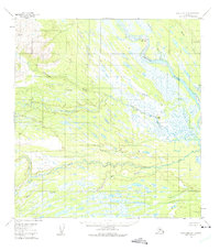
1954 Map of Talkeetna A-4
USGS Topo · Published 1961About this map
Kichatna River and the Yentna River converge in this mid-century survey of the Alaska interior, revealing a complex web of glacial braided streams and marshland. The landscape is defined by the high relief of Nin Ridge and the prominent Gold Hill, rising above the low-lying wetlands. A lone Cabin near Youngstown Bend serves as the only evidence of human habitation in this vast drainage system, highlighting the area's isolation during the 1950s.
Find a feature on this map
12 named features on this map. Tap any name to fly to it.
Don’t see what you’re looking for? This feature index may not catch every label — zoom into the map to look around manually.
Map Details
Editions of this 1954 Talkeetna A-4 Map
2 editions found
Other maps of this area

1949 · Tyonek
USGS Topo · 1:250,000

1950 · Talkeetna
USGS Topo · 1:250,000

1951 · Talkeetna
USGS Topo · 1:250,000

1951 · Tyonek
USGS Topo · 1:250,000

1954 · Talkeetna A-3
USGS Topo · 1:63,360

1954 · Tyonek D-5
USGS Topo · 1:63,360

1954 · Tyonek D-4
USGS Topo · 1:63,360

1954 · Talkeetna B-4
USGS Topo · 1:63,360

1954 · Talkeetna B-3
USGS Topo · 1:63,360

1958 · Tyonek D-6
USGS Topo · 1:63,360