
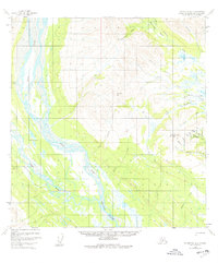
1954 Map of Talkeetna B-4
USGS Topo · Published 1961About this map
The confluence of the East Fork Yentna River and the West Fork Yentna River dominates this mid-century Alaskan landscape. The terrain is defined by massive natural features like Mt Kliskon and Fairview Mountain, with the hydrological network weaving through the Sunflower Basin and feeding into Midway Lakes. Human presence is sparse, marked primarily by isolated Cabins and a primitive transportation network. An Airstrip and a Tractor Trail near Camp Creek indicate the era's reliance on air and tracked transport for remote access. Prospecting and small-scale operations are suggested by names like Bonanza Creek, Chicago Gulch, and Ohn Gulch, while the naming of Fourth-of-July Creek hints at the seasonal movements of early arrivals in this interior region.
Find a feature on this map
31 named features on this map. Tap any name to fly to it.
Don’t see what you’re looking for? This feature index may not catch every label — zoom into the map to look around manually.
Map Details
Editions of this 1954 Talkeetna B-4 Map
2 editions found
Other maps of this area

1950 · Talkeetna
USGS Topo · 1:250,000

1951 · Talkeetna
USGS Topo · 1:250,000

1954 · Talkeetna A-3
USGS Topo · 1:63,360

1954 · Talkeetna A-4
USGS Topo · 1:63,360

1954 · Talkeetna B-3
USGS Topo · 1:63,360

1958 · Talkeetna A-5
USGS Topo · 1:63,360

1958 · Talkeetna B-5
USGS Topo · 1:63,360

1958 · Talkeetna C-4
USGS Topo · 1:63,360

1958 · Talkeetna C-3
USGS Topo · 1:63,360

1958 · Talkeetna C-5
USGS Topo · 1:63,360