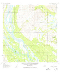
1954 Map of Talkeetna B-4
USGS Topo · Published 1977About this map
The East Fork Yentna River and West Fork Yentna River dominate this interior landscape, carving a complex network of braids and gravel bars through the valley floor. High ground is marked by prominent peaks such as Mt Kliskon and Fairview Mountain, the latter overlooking a localized concentration of mining activity. Evidence of industrial efforts is visible near the eastern boundary, where dredge tailings and several named gulches, including Fergy Gulch and Wagner Gulch, suggest a history of placer gold operations.
Find a feature on this map
38 named features on this map. Tap any name to fly to it.
Don’t see what you’re looking for? This feature index may not catch every label — zoom into the map to look around manually.
Map Details
Editions of this 1954 Talkeetna B-4 Map
2 editions found
Other maps of this area

1950 · Talkeetna
USGS Topo · 1:250,000

1951 · Talkeetna
USGS Topo · 1:250,000

1954 · Talkeetna A-3
USGS Topo · 1:63,360

1954 · Talkeetna B-4
USGS Topo · 1:63,360

1954 · Talkeetna A-4
USGS Topo · 1:63,360

1954 · Talkeetna B-3
USGS Topo · 1:63,360

1958 · Talkeetna A-5
USGS Topo · 1:63,360

1958 · Talkeetna B-5
USGS Topo · 1:63,360

1958 · Talkeetna C-4
USGS Topo · 1:63,360

1958 · Talkeetna C-3
USGS Topo · 1:63,360