1958 Map of Talkeetna C-5
USGS Topo · Published 1964About this map
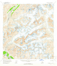
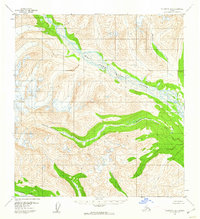
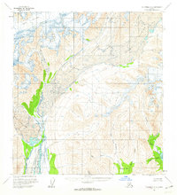
Mount Dall dominates this high-altitude Alaskan landscape, where massive ice fields and active glacial movement define the geography. Surveyed in the late 1950s, the map documents the expansive Surprise Glacier and Dall Glacier, both of which are marked by extensive fields of crevasses that indicate the constant shifting of the ice. The drainage patterns of the Alaska Range are clearly visible as meltwater feeds into the Tonzona River to the northwest and the West Fork Yentna River in the south. The absence of any roads or trails underscores the wilderness character of this region during the mid-20th century. Local water features like Cascade Creek provide further detail for navigating the complex terrain surrounding the central peaks, offering a precise record of the ice margins before modern climatic shifts.
Find a feature on this map
7 named features on this map. Tap any name to fly to it.
Don’t see what you’re looking for? This feature index may not catch every label — zoom into the map to look around manually.
Map Details
Editions of this 1958 Talkeetna C-5 Map
2 editions found

Other maps of this area

1950 · Talkeetna
USGS Topo · 1:250,000
1951 · Talkeetna
USGS Topo · 1:250,000
1954 · Talkeetna B-4
USGS Topo · 1:63,360
1958 · Talkeetna D-6
USGS Topo · 1:63,360
1958 · Talkeetna B-5
USGS Topo · 1:63,360
1958 · Talkeetna B-6
USGS Topo · 1:63,360
1958 · Talkeetna C-6
USGS Topo · 1:63,360
1958 · Talkeetna D-5
USGS Topo · 1:63,360
1958 · Talkeetna C-4
USGS Topo · 1:63,360
1958 · Talkeetna D-4
USGS Topo · 1:63,360