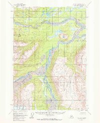
1958 Map of Tyonek D-6
USGS Topo · Published 1972About this map
The glacial waters of the Hayes Glacier dominate this mid-century view of the Matanuska-Susitna region, feeding into a complex braided drainage system where the Hayes River and Trimble River converge. The landscape is defined by its transition from high ice fields to the lower river basins, where the wide Skwentna River snakes through the northern portion of the quadrangle. Scattered throughout this wilderness are clear landmarks for navigation and survival, including several lakes like Red Lake, Finger Lake, and Red Salmon Lake.
Find a feature on this map
12 named features on this map. Tap any name to fly to it.
Don’t see what you’re looking for? This feature index may not catch every label — zoom into the map to look around manually.
Map Details
Editions of this 1958 Tyonek D-6 Map
2 editions found
Other maps of this area

1949 · Tyonek
USGS Topo · 1:250,000

1950 · Talkeetna
USGS Topo · 1:250,000

1951 · Talkeetna
USGS Topo · 1:250,000

1951 · Tyonek
USGS Topo · 1:250,000

1954 · Tyonek C-5
USGS Topo · 1:63,360

1954 · Tyonek D-5
USGS Topo · 1:63,360

1954 · Talkeetna A-4
USGS Topo · 1:63,360

1958 · Tyonek C-6
USGS Topo · 1:63,360

1958 · Tyonek D-6
USGS Topo · 1:63,360

1958 · Talkeetna A-5
USGS Topo · 1:63,360