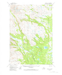
1954 Map of Tyonek C-5
USGS Topo · Published 1973About this map
Talachulitna Lake and the neighboring Judd Lake anchor the southeastern portion of this Alaskan interior landscape, a region defined by an intricate network of drainages during the mid-1950s. The map illustrates a transitional environment where unnamed marshlands meet the rising elevations of VABM Tal 4094 and VABM Trium 3101. Remote human activity is recorded by a single Cabin and a dedicated Landing Strip near Friday Creek, indicating the necessity of bush planes for regional access. Several watercourses carry names suggesting early prospector or seasonal exploration, including Coal Creek, its West Fork, and a sequence of temporal labels: Friday Creek, Saturday Creek, and Deep Creek. The terrain is characterized by complex hydrology, with numerous small bodies of water like Aho Lake and Kitty Lake scattered throughout the drainage basins of Talachulitna Creek and Alder Creek.
Find a feature on this map
15 named features on this map. Tap any name to fly to it.
Don’t see what you’re looking for? This feature index may not catch every label — zoom into the map to look around manually.
Map Details
Editions of this 1954 Tyonek C-5 Map
2 editions found
Other maps of this area

1949 · Tyonek
USGS Topo · 1:250,000

1951 · Tyonek
USGS Topo · 1:250,000

1954 · Tyonek C-5
USGS Topo · 1:63,360

1954 · Tyonek C-4
USGS Topo · 1:63,360

1954 · Tyonek B-4
USGS Topo · 1:63,360

1954 · Tyonek D-5
USGS Topo · 1:63,360

1954 · Tyonek D-4
USGS Topo · 1:63,360

1958 · Tyonek C-6
USGS Topo · 1:63,360

1958 · Tyonek B-5
USGS Topo · 1:63,360

1958 · Tyonek B-6
USGS Topo · 1:63,360