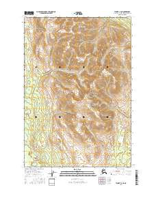
2016 Map of Tyonek C-4 NE
USGS Topo · Published 2016About this map
Beluga Mtn dominates the central portion of this 2016 survey, serving as a significant topographic anchor for the surrounding wilderness in the Matanuska-Susitna Borough. The landscape is defined by its complex drainage network, where the Talachulitna River winds through the southern reaches, joined by several major tributaries. Small watercourses like Clear Cr, Texas Cr, and Bear Cr carve through the high-elevation terrain, indicating a high-alpine environment where snowmelt and seasonal runoff shape the ground. The presence of the Public Land Survey System grid, including boundaries for t19n r11w and t18n r10w, shows the formal division of this remote Alaskan interior, though the map remains largely devoid of human-named settlements or man-made structures, highlighting the region's preservation as a primitive natural corridor.
Find a feature on this map
9 named features on this map. Tap any name to fly to it.
Don’t see what you’re looking for? This feature index may not catch every label — zoom into the map to look around manually.
Map Details
Editions of this 2016 Tyonek C-4 NE Map
This is the sole edition of this map. No revisions or reprints were ever made.
Other maps of this area

1949 · Tyonek
USGS Topo · 1:250,000

1951 · Tyonek
USGS Topo · 1:250,000

1954 · Tyonek D-3
USGS Topo · 1:63,360

1954 · Tyonek C-4
USGS Topo · 1:63,360

1954 · Tyonek D-4
USGS Topo · 1:63,360

1954 · Tyonek C-3
USGS Topo · 1:63,360

1958 · Tyonek
USGS Topo · 1:250,000

1965 · Tyonek
USGS Topo · 1:250,000
1993 · Tyonek D-3
USGS Topo · 1:63,360
1993 · Tyonek D-4
USGS Topo · 1:63,360