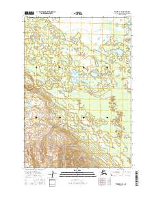
2016 Map of Tyonek D-4 SE
USGS Topo · Published 2016About this map
Sevenmile Lake and Eightmile Lake dominate the northern wetlands of this Matanuska-Susitna borough landscape. The terrain is defined by an intricate network of surface water and drainage systems, where the meandering course of Deep Cr cuts through the central sections while Clear Cr drains the southeastern reaches. To the west, Top Lake sits on the edge of the survey area, marking a transition in the local hydrology. The absence of established settlements or major roads highlights a wilderness character typical of the Cook Inlet region, where the primary identifiers are the township and range lines of the Public Land Survey System. These boundaries, including t21n r11w and t20n r10w, provide the essential grid for locating specific land parcels in an otherwise open and untamed Alaskan interior.
Find a feature on this map
11 named features on this map. Tap any name to fly to it.
Don’t see what you’re looking for? This feature index may not catch every label — zoom into the map to look around manually.
Map Details
Editions of this 2016 Tyonek D-4 SE Map
This is the sole edition of this map. No revisions or reprints were ever made.
Other maps of this area

1949 · Tyonek
USGS Topo · 1:250,000

1951 · Tyonek
USGS Topo · 1:250,000

1954 · Tyonek D-3
USGS Topo · 1:63,360

1954 · Tyonek C-4
USGS Topo · 1:63,360

1954 · Tyonek D-4
USGS Topo · 1:63,360

1954 · Tyonek C-3
USGS Topo · 1:63,360

1958 · Tyonek
USGS Topo · 1:250,000

1965 · Tyonek
USGS Topo · 1:250,000
1993 · Tyonek D-3
USGS Topo · 1:63,360
1993 · Tyonek D-4
USGS Topo · 1:63,360