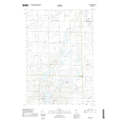
2019 Map of Typo Lake
USGS Topo · Published 2019About this map
Typo Lake and the branching waters of the Sunrise River system dominate this landscape on the border of Isanti, Anoka, and Chisago Counties. The area is defined by a dense cluster of glacial lakes, including the central Fawn Lake, Hoffman Lake, and the expansive Martin Lake to the south near the community of Martin-Lake. Small settlements like Weber and the established town of Stacy anchor the local road network, which transitions from organized grids to winding routes dictated by the wetlands. Local heritage is preserved in several rural burial grounds such as Linwood Township Cem and the Oxford-Union Cem, while the northern portion of the map shows the growth of North Branch. The presence of the West Branch Sunrise River and its various tributaries illustrates the complex hydrology that has historically shaped the development of these lakefront communities.
Find a feature on this map
133 named features on this map. Tap any name to fly to it.
Don’t see what you’re looking for? This feature index may not catch every label — zoom into the map to look around manually.
Map Details
Editions of this 2019 Typo Lake Map
This is the sole edition of this map. No revisions or reprints were ever made.
Other maps of this area

1950 · Rush City
USGS Topo · 1:48,000

1953 · Stillwater
USGS Topo · 1:250,000

1955 · Rush City
USGS Topo · 1:62,500

1955 · Forest Lake
USGS Topo · 1:62,500

1955 · Isanti
USGS Topo · 1:62,500

1955 · Stillwater
USGS Topo · 1:250,000

1958 · Stillwater
USGS Topo · 1:250,000

1961 · Cambridge
USGS Topo · 1:62,500

1965 · Stillwater
USGS Topo · 1:250,000
1974 · Stacy
USGS Topo · 1:24,000