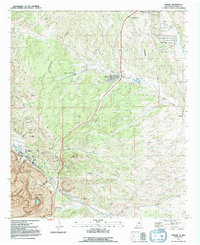
1992 Map of Tyrone
USGS Topo · Published 1992About this map
The Continental Divide winds through the southwestern corner of Grant County, anchoring a landscape defined by the massive industrial footprint of the Tyrone Mine. This late-twentieth-century survey illustrates the juxtaposition of intensive resource extraction with expanding residential developments like Silver Acres and the modern town of Tyrone. While the mining operations dominate the terrain with numerous mine dumps and water-related infrastructure, the map also captures the older, original Tyrone (Site) near Brick Kiln Gulch, providing a critical reference for local historians. Significant institutional and logistical landmarks are present at the northern edge of the quadrangle, including the Harrison A Schmitt Sch and the Turner Ridgeport Airport. The Little Burro Mountains rise to the west, where Indian Peak and Bald Mountain overlook a network of canyons including Negro Canyon and Redrock Canyon.
Find a feature on this map
34 named features on this map. Tap any name to fly to it.
Don’t see what you’re looking for? This feature index may not catch every label — zoom into the map to look around manually.
Map Details
Editions of this 1992 Tyrone Map
This is the sole edition of this map. No revisions or reprints were ever made.
Other maps of this area

1909 · Silver City
USGS Topo · 1:125,000

1947 · Fort Bayard
USGS Topo · 1:24,000

1949 · Fort Bayard
USGS Topo · 1:24,000

1949 · Whitewater
USGS Topo · 1:24,000

1949 · Hurley West
USGS Topo · 1:24,000

1949 · Circle Mesa
USGS Topo · 1:24,000

1950 · Tyrone
USGS Topo · 1:24,000

1950 · White Signal
USGS Topo · 1:24,000

1950 · Wind Mountain
USGS Topo · 1:24,000

1950 · Burro Peak
USGS Topo · 1:24,000