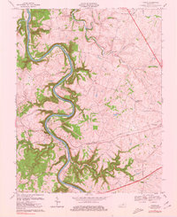
1976 Map of Tyrone
USGS Topo · Published 1980About this map
The Kentucky River carves a deep, sinuous path through the limestone of central Kentucky, defining the boundary between Anderson and Woodford Counties. Near the center of this 1970s landscape, the village of Tyrone sits at a strategic bend where the Southern railroad crosses the water, supported by industrial infrastructure including a powerplant and nearby quarry. The river is managed by Lock No 5, illustrating the importance of waterway navigation to the local economy alongside the rail corridor. To the east, the terrain levels into the bluegrass uplands near Versailles, where the Woodford Hills Country Club and family-named routes like Mc Cowans Ferry Road appear. Rural life is anchored by small settlements and community hubs such as Glenns Creek Ch, Millville, and McKees Crossroads, which mark the intersection of historic land tracts and more modern developments like the Parkway.
Find a feature on this map
48 named features on this map. Tap any name to fly to it.
Don’t see what you’re looking for? This feature index may not catch every label — zoom into the map to look around manually.
Map Details
Editions of this 1976 Tyrone Map
This is the sole edition of this map. No revisions or reprints were ever made.
Other maps of this area

1905 · Harrodsburg
USGS Topo · 1:125,000

1906 · Georgetown
USGS Topo · 1:62,500

1908 · Georgetown
USGS Topo · 1:62,500

1922 · Frankfort
USGS Topo · 1:48,000

1924 · Frankfort
USGS Topo · 1:62,500

1951 · Lawrenceburg
USGS Topo · 1:24,000

1952 · Keene
USGS Topo · 1:24,000

1952 · Salvisa
USGS Topo · 1:24,000

1952 · Mc Brayer
USGS Topo · 1:24,000

1952 · Midway
USGS Topo · 1:24,000