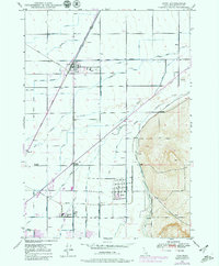
1948 Map of Ucon
USGS Topo · Published 1979About this map
The intensive irrigation network of the Upper Snake River Valley defines the landscape around Ucon and Iona, where a complex system of waterways like the South Branch Harrison Canal and Farmers Friend Canal transformed the high desert into productive farmland. Settled at the intersection of these vital water lines and the Union Pacific railroad, communities such as Lincoln and Beachs Corner grew to serve the agricultural needs of Bonneville County. The map reveals the expansion of Idaho Falls at the southern margin, while also preserving localized landmarks like the St Leon School and Lincoln Cem. This survey, updated with purple revisions from 1976, shows how early 20th-century settlement patterns and water rights—represented by dozens of named ditches such as the Biby Ditch and Koster Lateral—remained the backbone of the region's economy decades later.
Find a feature on this map
36 named features on this map. Tap any name to fly to it.
Don’t see what you’re looking for? This feature index may not catch every label — zoom into the map to look around manually.
Map Details
Editions of this 1948 Ucon Map
3 editions found
Other maps of this area

1924 · Ammon
USGS Topo · 1:62,500

1948 · Rigby
USGS Topo · 1:24,000

1948 · Lewisville
USGS Topo · 1:24,000

1948 · Idaho Falls North
USGS Topo · 1:24,000

1948 · Idaho Falls South
USGS Topo · 1:24,000

1948 · Ucon
USGS Topo · 1:24,000

1949 · Ucon
USGS Topo · 1:24,000

1949 · Idaho Falls North
USGS Topo · 1:24,000

1949 · Rigby
USGS Topo · 1:24,000

1949 · Lewisville
USGS Topo · 1:24,000